
Trails in Douglas County abound

Douglas Umpqua Basin area is renowned as an outdoor recreation wonderland. However, with the sheer volume of hiking destinations, figuring out the best trails can be a daunting task. Here is a short guide to some of the best local hiking options:
The North Bank Habitat Management Area: The NBHMA is a 6,500 acre former ranch located just 20 minutes from the UCC campus up North Bank road. Miles of trails branch out from the park’s two trail heads, giving a huge range of options from short walks to epic, all-day traverses of the area’s ridges.
How to get there: After leaving UCC, drive north on Highway 99 approximately 1.8 miles and take a right onto North Bank Road. Drive for another 5.5 miles until a large parking area appears on the left. This is the west parking area. You can drive another 6.5 miles (just past the huge power lines that cross the river) to the driveway of the main entrance but note that the parking area there is only open from Friday to Monday. On other days, park at the gate, making certain you leave enough room for employee vehicles to pass
The North Umpqua Trail: The North Umpqua Trail, or NUT, is one of the premiere long-distance trails in the Northwest, stretching 79 miles from the base of Mt. Thielsen and ending at Swiftwater Park just outside of Glide. While most people don’t have the ambition or the time to complete the entire trail, it is broken into multiple segments allowing for easier day hikes. Trail heads can be found at Swiftwater Park, the recently completed Tioga footbridge, the Wright Creek bridge, the Mott Bridge and at Apple Creek.
How to get there: Drive east on Highway 138 (the North Umpqua Highway) for approximately 22 miles to Swiftwater Park. Cross the bridge and pull into the parking area on the left. A kiosk gives details about the trail and the segment. To find any of the other trail heads, continue past Swiftwater Park on Highway 138. Each of the afore-mentioned segments should be well signed and easy to find.
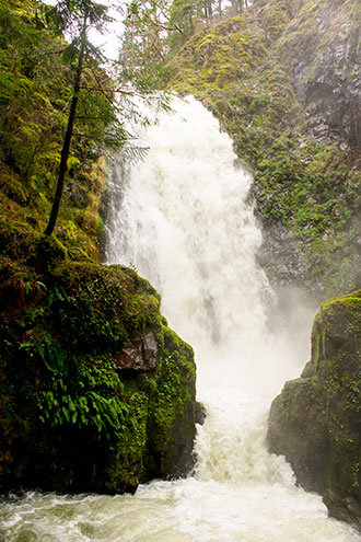
North Umpqua Waterfalls: The waterfall hikes of the North Umpqua are some of the most popular hikes in all of Douglas County and for good reason. Susan Creek, Fall Creek, Toketee and Watson Falls are all spectacular hikes and short enough that many visitors will hike more than one in a single day. Watson Falls is notable as being the highest waterfall in Southern Oregon and the third highest waterfall in the state.
How to get there: All of the falls are located off of Highway 138. Susan Creek Falls is the closest to Roseburg and can be found at milepost 28.2 (approximately 6 miles past Swiftwater Park). An easy 0.8 mile trail leads to the base of this spectacular 50-foot waterfall. Fall Creek Falls is another four miles up the highway, and the trail is approximately one mile in length. To find Toketee Falls, drive to milepost 58.6, turn left onto Road 34, keep left at the ‘Y’ intersection and cross the bridge. The trail head road is a short drive to the left after the bridge. The trail to the falls is 0.4 miles in length. Watson Falls can be found on the right at milepost 60.5, where another short (0.4 mile) trail leads to a viewpoint.